AI VIDEO
Von der Briefmarke ins Weltall.
Eine alte französische Briefmarke liegt auf einem Holztisch. Dreizehn Sekunden später steht die Kamera 400 Kilometer über Westeuropa — in einer einzigen Fahrt, ohne einen Schnitt. Vier Referenzbilder aus ChatGPT legen die Maßstabsstufen fest, ein Prompt für Seedance 2.5 verbindet sie.
- ChatGPT
- Artlist
- 40 Min
- Fortgeschritten
ERGEBNIS
Das ist dabei rausgekommen.
- 4Referenzbilder auf derselben Blickachse
- 5Prompts — vier für Bilder, einer fürs Video
- 13 seine durchgehende Kamerafahrt
- 0Schnitte, Blenden, Überblendungen
-
 Briefmarke0:00 · Makro
-
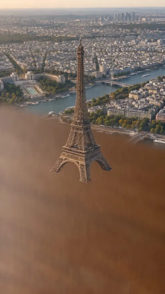 Die Tinte wird echt0:03 · Übergang
-
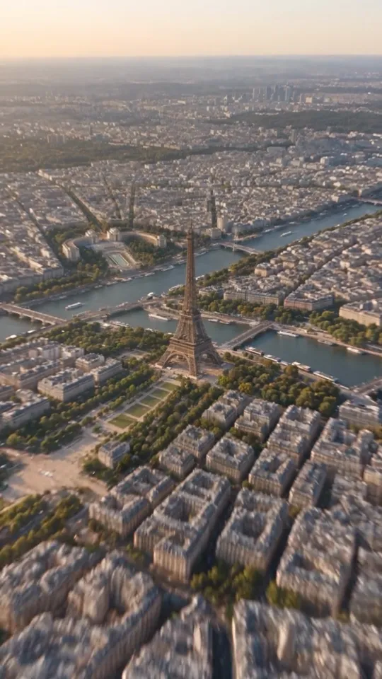 Echtes Paris0:05 · Luftaufnahme
-
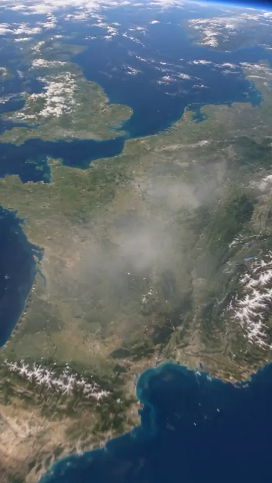 Ganz Frankreich0:09 · Satellit
-
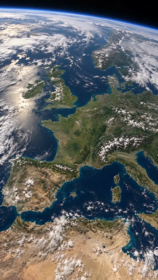 Orbit0:13 · Schlussbild
DIE MASSSTABSKETTE
Vier Bilder, eine Blickachse.
Die vier Bilder sind keine vier Szenen, sondern vier Haltepunkte auf derselben Kamerafahrt. Jedes wird mit dem vorherigen zusammen erzeugt und erbt dessen Blickrichtung, Lichtstimmung und geografische Mitte — der Eiffelturm sitzt auf allen vieren an derselben Stelle im Bild. Genau deshalb liest Seedance die Reihe später als Höhenmeter und nicht als Schnittfolge.
 ChatGPT
 Artlist
-
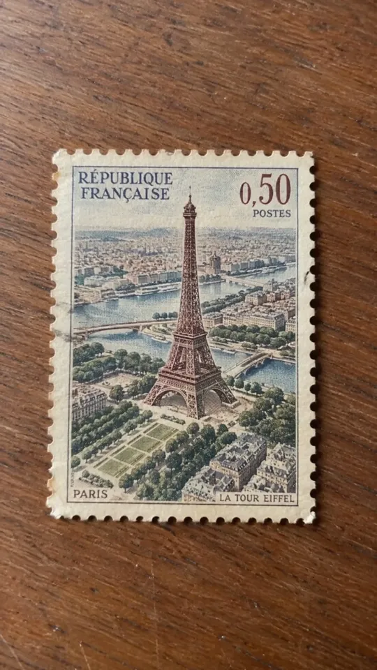
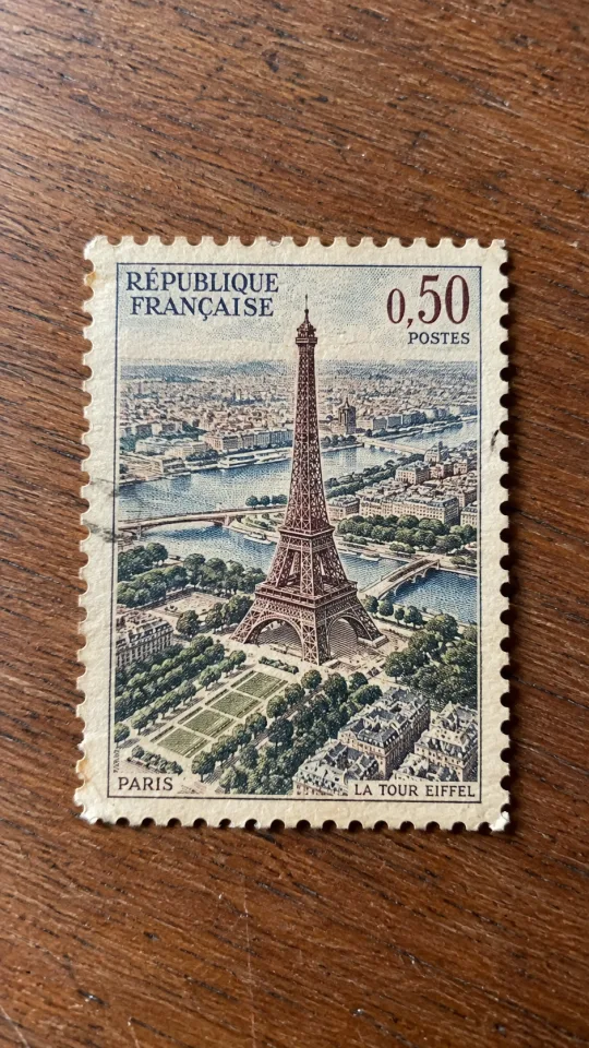 Bild 1 · Die BriefmarkeStartbild — legt Licht und Tisch fest
-
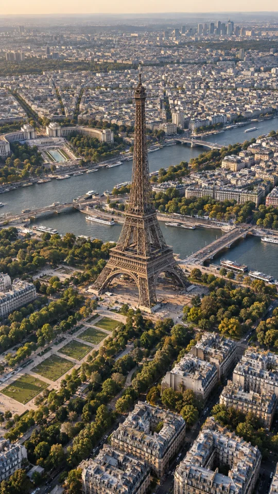 Bild 2 · Paris von obenDieselbe Stelle, nur echt
-
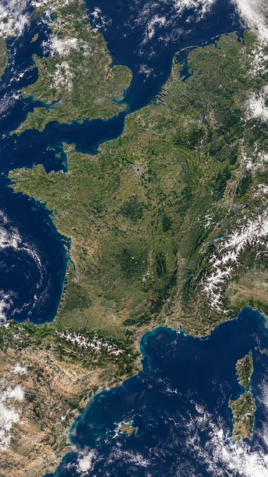 Bild 3 · Ganz FrankreichSatellitenhöhe, keine Landkarte
-
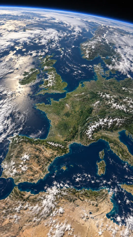 Bild 4 · Aus dem OrbitSchlussframe, 400 km Höhe
ANLEITUNG
So baust du es nach.
-
Die Briefmarke muss von schräg oben gedruckt sein
Das erste Bild entscheidet über den ganzen Clip. Prompt 1 fragt keine hübsche Briefmarke ab, sondern eine bestimmte: die gedruckte Illustration zeigt den Eiffelturm
from a slightly elevated aerial perspective rather than a straight frontal tourist view, und der Bildaufbau soll grob der echten Geografie von Paris entsprechen. Nimmst du die klassische Frontalansicht vom Boden aus, müsste die Kamera später kippen, um zur echten Luftaufnahme zu passen — und genau dieses Kippen sieht aus wie ein versteckter Schnitt. -
Bild 2 — dieselbe Stelle, nur echt
Briefmarke als Referenz anhängen, Prompt 2 dazu. Der tragende Satz darin: der Eiffelturm muss
exactly the same central visual position and orientationeinnehmen wie auf der Briefmarke. Dazu die Ansage, dass es jetzt weder Papier noch Tisch noch Rand gibt — sonst baut das Modell die Luftaufnahme gern wieder in eine Briefmarke hinein. Champ de Mars, Seine, Pont d’Iéna und Trocadéro stehen namentlich im Prompt, damit die Geografie stimmt und nicht nur die Stimmung. -
Bild 3 — ganz Frankreich, aber keine Landkarte
Jetzt springt der Maßstab zum ersten Mal weit. Prompt 3 hält die Achse fest (
maintaining the exact same viewing axis) und zählt auf, was sichtbar sein muss: Atlantikküste, Biskaya, Ärmelkanal, Mittelmeer, Pyrenäen, Alpen, Rhonetal. Genauso wichtig ist, was verboten ist — keine Landesgrenzen, keine leuchtenden Umrisse, keine Beschriftung. Frankreich soll durch Küstenlinie und Gelände erkennbar sein, nicht durch Kartengrafik. -
Bild 4 — der Schlussframe aus dem Orbit
Das letzte Bild ist das Ziel der Fahrt und bestimmt, wo der Clip stehen bleibt. Prompt 4 verlangt den Blick aus rund 400 Kilometern Höhe, Frankreich weiterhin nahe der Bildmitte, eine dünne physikalisch plausible Atmosphärenschicht am oberen Rand und eine gerade erst sichtbare Erdkrümmung. Die Verbotsliste ist hier am längsten: keine übertriebene Krümmung, kein Science-Fiction-Leuchten, keine dominierenden Sterne.
-
Vier Bilder hochladen — die Reihenfolge ist die Flugbahn
In Seedance gehen die Bilder in genau der Reihenfolge rein, in der die Kamera sie passiert: Briefmarke, Paris, Frankreich, Orbit. Der Masterprompt spricht sie als
@Image 1bis@Image 4an, und diese Nummern kommen aus dem Upload-Slot, nicht aus dem Dateinamen. Vertauschst du zwei, fährt die Kamera zwischendurch wieder nach unten. -
Masterprompt rein: erst die Regel, dann die Sekundenfenster
Der Videoprompt beginnt nicht mit der Beschreibung, sondern mit der Regel: eine einzige ununterbrochene Einstellung, keine Schnitte, keine Blenden. Erst danach kommt der Satz, auf den alles hinausläuft — die vier Bilder sind
NOT separate scenes, sondern aufeinanderfolgende Maßstabspunkte auf einer Bahn. Darunter stehen vier Zeitfenster (0–3, 3–6, 6–10, 10–15 Sekunden), die beschreiben, wo die Kamera wann ist und wie schnell sie sich bewegt. -
Einmal laufen lassen — und auf zwei Stellen achten
Die ersten drei Sekunden und der Übergang bei Sekunde sechs sind die Stellen, an denen es kippt. Am Anfang darf die Briefmarke nicht einfach kleiner werden, und beim Übergang zur Landesfläche darf kein Nachbild des Tisches stehen bleiben. Beides kannst du nicht im Schnitt reparieren — bei einem Take gibt es nichts zu schneiden. Läuft eine der beiden Stellen daneben, geht der Clip neu, nicht das Zwischenbild.
CREATOR KIT
Alles, was du brauchst.
Create an ultra-photorealistic vertical 9:16 smartphone macro photograph of a small vintage French postage stamp lying perfectly flat on a real warm walnut wooden table.

Camera positioned approximately 25 centimeters above the table, almost directly overhead with only a very slight natural perspective angle.

The postage stamp is centered and fills approximately 45 percent of the frame.

The physical stamp is approximately 2.5 centimeters wide, with authentic off-white fibrous paper texture, subtle aging, tiny imperfections, slightly uneven perforated edges and realistic contact shadow against the wooden surface.

The printed artwork on the stamp depicts Paris in an elegant vintage French engraved illustration style.

The Eiffel Tower is the central recognizable landmark.

IMPORTANT:
Show the Eiffel Tower from a slightly elevated aerial perspective rather than a straight frontal tourist view.

Include the Champ de Mars beneath it, the Seine River nearby and subtle surrounding Parisian urban structures.

The composition of the printed artwork should roughly correspond to the real geographic layout of central Paris so that it can later transform seamlessly into real Paris.

Muted vintage colors:
warm cream,
desaturated blue,
deep burgundy,
subtle faded green,
aged ink.

The stamp should look physically real, photographed with a modern smartphone camera.

Natural daylight from the upper left.
Realistic soft shadow.
Visible wooden grain.
Extremely realistic paper fibers and printing texture.

No hands.
No floating objects.
No dramatic studio lighting.
No cinematic background blur.
No fantasy.
No text outside the stamp.
No watermark.

The entire scene must look like an ordinary real photograph someone could take at home.

Vertical 9:16.
Ultra photorealistic.
8K detail.
Create an ultra-photorealistic vertical 9:16 aerial photograph of real Paris, France, viewed from several hundred meters above the city.

The Eiffel Tower must occupy exactly the same central visual position and orientation as the Eiffel Tower illustration in the previous postage stamp reference.

Camera is looking almost vertically downward with a slight cinematic perspective.

Clearly show the real Eiffel Tower,
Champ de Mars,
the Seine River,
Pont d'Iéna,
Trocadéro,
dense Haussmann-style Parisian city blocks,
streets,
trees and rooftops.

The printed illustration from the postage stamp has now become completely real.

There is absolutely no postage stamp,
no paper,
no wooden table,
no artificial border.

Everything is now full-scale real-world Paris.

Maintain geographically believable urban structure.

Natural late-afternoon daylight matching the direction and warmth of the previous reference image.

Clear atmosphere.
Realistic shadows.
Subtle atmospheric depth.

The Eiffel Tower remains the visual anchor while the surrounding city stretches naturally into the distance.

Extremely realistic aerial photography.
Authentic French architecture.
Realistic streets and urban density.
No miniature effect.
No tilt-shift.
No fantasy.
No text.
No map labels.
No artificial borders.

Vertical 9:16.
Photorealistic.
8K aerial photography.
Create an ultra-photorealistic vertical 9:16 high-altitude satellite-style view centered geographically over Paris, France.

The camera has pulled thousands of kilometers upward from the previous aerial view while maintaining the exact same viewing axis.

All of metropolitan France is now visible within the frame.

France must have geographically accurate real-world proportions and coastline.

Clearly recognizable geographic features:

the Atlantic coastline,
Bay of Biscay,
English Channel,
Mediterranean coast,
the Pyrenees between France and Spain,
the Alps along southeastern France,
the Rhône valley,
large-scale French terrain variation.

Paris remains at its geographically correct location in north-central France and represents the same physical point beneath the camera as the Eiffel Tower from the previous image.

Neighboring countries are naturally visible around France:
Spain,
Belgium,
Germany,
Switzerland,
Italy,
Luxembourg.

IMPORTANT:
Do not draw political borders.

France must be recognizable naturally through coastline, geography and terrain, not through glowing outlines or artificial map graphics.

Include sparse realistic cloud formations at different altitudes, but keep most of France unobstructed.

Natural daylight.
Realistic atmospheric haze.
Realistic vegetation and terrain colors.
Deep blue Atlantic Ocean and Mediterranean Sea.

The image must look like genuine high-resolution Earth observation satellite imagery.

No labels.
No borders.
No text.
No fantasy geography.
No exaggerated colors.
No artificial country outline.

Vertical 9:16.
NASA / ESA Earth observation realism.
Ultra detailed.
Create an extraordinarily photorealistic vertical 9:16 view of Western Europe from low Earth orbit, approximately 400 kilometers above Earth.

Continue from the exact geographic viewing axis of the previous France satellite reference.

France remains prominently visible below the camera, surrounded by Western Europe.

Clearly recognizable natural geography includes:

France,
Spain,
the English Channel,
southern United Kingdom,
Belgium,
Germany,
Switzerland,
northern Italy,
the Alps,
the Pyrenees,
Atlantic Ocean,
Mediterranean Sea.

France remains close to the visual center of the composition.

The camera has now pulled far enough away that subtle curvature of Earth becomes visible.

At the upper edge of the planet, show a thin physically realistic blue atmospheric layer fading naturally into deep black space.

Large realistic cloud systems float above Europe and the Atlantic while leaving enough of France visible to recognize the geography.

Natural sunlight.
Physically realistic atmosphere.
Subtle atmospheric scattering.
Realistic ocean reflections.
True-to-life terrain colors.

The image should resemble a premium photograph captured from the International Space Station or a scientifically accurate cinematic Earth observation camera.

No country borders.
No glowing France outline.
No map labels.
No science-fiction effects.
No excessive atmospheric glow.
No exaggerated Earth curvature.
No stars dominating the background.
No fantasy continents.

Vertical 9:16.
Photorealistic.
NASA-style realism.
8K detail.
Create ONE SINGLE UNINTERRUPTED CONTINUOUS TAKE.

NO CUTS.
NO EDITS.
NO SCENE CHANGES.
NO CROSSFADE.
NO DISSOLVE.

The entire video is one impossible continuous vertical camera pullback,
starting only a few centimeters above a physical postage stamp
and ending approximately 400 kilometers above Earth.

Use the provided images as visual and geographic references for different
scale stages of the SAME continuous physical location.

@Image 1 defines the exact starting composition, physical postage stamp,
wooden table, lighting, colors and printed Eiffel Tower artwork.

@Image 2 defines what the same location must progressively become when
the camera reaches aerial altitude: real Paris, with the Eiffel Tower,
Champ de Mars, Seine and surrounding city.

@Image 3 defines the geography, orientation, terrain and appearance when
the camera reaches extreme altitude and all of France becomes visible.

@Image 4 defines the final low-Earth-orbit appearance, atmosphere,
Western Europe, Earth curvature and final camera framing.

IMPORTANT:
These reference images are NOT separate scenes.

Never cut or jump from one reference image to another.

They are consecutive scale reference points along one single continuous
camera trajectory.

The camera begins exactly above the physical postage stamp from @Image 1.

0–3 seconds:
Begin with an extreme close view of the real physical French postage stamp
lying on the wooden table.

Immediately begin smoothly pulling vertically upward.

As altitude increases, the printed Eiffel Tower begins gaining real physical
depth directly from the ink.

The flat illustration transforms progressively into three-dimensional reality.

The printed Eiffel Tower grows naturally into the real Eiffel Tower.
Printed grass becomes the real Champ de Mars.
Printed blue ink becomes the real Seine River.
Printed Paris buildings acquire real architecture, rooftops, streets,
windows and physical depth.

At the same time the apparent scale changes continuously.

Do NOT make the stamp simply shrink away.

Instead, the world represented inside the stamp becomes physically real
and expands until it completely replaces the paper surface.

The perforated stamp border naturally moves outside the camera's field
of view as the camera continues upward.

The wooden tabletop disappears naturally because the scene has now
become full-scale Paris.

3–6 seconds:
The camera is now hundreds of meters above completely real Paris.

Continue the EXACT SAME upward camera motion.

The Eiffel Tower stays geographically locked beneath the camera.

Paris becomes progressively smaller.

Individual streets and buildings become districts,
districts become the metropolitan area,
and surrounding countryside enters the frame.

There must never be a moment where the camera stops.

6–10 seconds:
Continue rapidly gaining altitude.

Paris becomes a tiny part of the landscape.

More and more of France naturally enters the frame.

The English Channel, Atlantic coast, Bay of Biscay,
Mediterranean coast, Pyrenees and Alps become visible
in geographically correct positions.

France must appear through real geography only.

Do not create a map.
Do not create borders.
Do not create labels.

Realistic cloud formations begin passing beneath the camera.

The camera moves through and above thin cloud layers while continuing
the exact same vertical trajectory.

10–15 seconds:
Continue accelerating smoothly upward through the upper atmosphere.

Western Europe becomes visible.

Atmospheric haze gradually becomes a thin blue atmospheric layer.

The horizon slowly enters the frame.

The sky naturally transitions from atmospheric blue to deep blue
and finally the blackness of space.

Subtle physically realistic Earth curvature develops progressively.

Finish approximately 400 kilometers above Earth in low Earth orbit,
matching the visual geography and framing of @Image 4.

France and Western Europe must still be recognizable below.

Throughout the ENTIRE video:

ONE camera.
ONE lens trajectory.
ONE physical location.
ONE continuous upward movement.

The camera is always moving AWAY from the surface.

Maintain geographic orientation throughout.

The Eiffel Tower, Paris, France and Western Europe must represent the
same geographic point at progressively larger scales.

The scale change should feel breathtaking but physically coherent.

Gradually accelerate the camera:
slow and detailed near the postage stamp,
faster above Paris,
very fast at atmospheric altitude,
then smoothly decelerate for the final orbital reveal.

Photorealistic.
Cinematic realism.
Realistic motion blur.
Natural sunlight.
Real-world physics.
Real geographic scale.
Authentic atmosphere.
NASA-quality final Earth imagery.

Absolutely NO:
cuts,
scene transitions,
crossfades,
dissolves,
teleportation,
camera rotation,
camera orbit,
random sideways movement,
zooming back in,
fake country borders,
map graphics,
text,
glowing outlines,
fantasy effects,
sudden geography changes,
shrinking postage stamp floating on the table.

The viewer should genuinely believe the camera has traveled continuously
from two centimeters above a postage stamp to low Earth orbit
without ever stopping or cutting.
SETTINGS
Die Einstellungen im Überblick.
| Plattform | Artlist, AI-Bereich |
|---|---|
| Videomodell | Seedance 2.5 |
| Bildmodell | ChatGPT, Bildgenerierung |
| Format | 9:16, hochkant |
| Länge | 13 Sekunden, ein Take |
| Referenzbilder | 4, Reihenfolge zwingend |
| Bild-Prompts | 4, jeder hängt am vorherigen Bild |
| Kamera | nur vertikal nach oben, keine Drehung |
| Ton | kommt aus Seedance, nicht nachvertont |
WORAUF ES ANKOMMT
Darauf musst du achten.
Die Briefmarke schrumpft nicht — sie wird zur Welt
Das ist der eine Satz, der den Clip von einem gewöhnlichen Zoom-out trennt:
Do NOT make the stamp simply shrink away.Stattdessen soll die Welt innerhalb der Marke physisch echt werden und sich ausdehnen, bis sie das Papier ersetzt — die Perforation wandert dabei nach außen aus dem Bild, statt in der Mitte kleiner zu werden. Ohne diese Ansage bekommst du eine Briefmarke, die auf einem immer größeren Tisch herumliegt.Jedes Bild wird gegen das vorherige erzeugt, nicht gegen den Text
In allen drei Folge-Prompts steht dieselbe Klammer:
continue from the exact geographic viewing axis of the previous reference. Deshalb hängst du beim Generieren immer das vorherige Bild mit an. Sprachlich beschreiben lässt sich eine Blickachse kaum — „von oben“ gibt es in tausend Varianten. Als Bild ist sie eindeutig, und das Modell übernimmt sie mitsamt Lichtrichtung und Farbstimmung.Die Beschleunigung muss im Prompt stehen
Eine gleichmäßige Fahrt über dreizehn Sekunden wirkt tot, weil sich am Anfang zu viel und am Ende zu wenig ändert. Der Prompt gibt deshalb eine Kurve vor:
slow and detailed near the postage stamp, faster above Paris, very fast at atmospheric altitude, then smoothly decelerate for the final orbital reveal. Der langsame Start ist kein Schmuck — nur dort sieht man überhaupt, dass Tinte zu Architektur wird.Verbote tragen den Clip, nicht die Beschreibung
Der Masterprompt verbietet zweimal dasselbe: oben in Großbuchstaben (
NO CUTS. NO EDITS. NO SCENE CHANGES.) und unten noch einmal als Liste, dort zusätzlich Kameradrehung, Orbit, seitliche Bewegung und erneutes Hereinzoomen. Das wirkt redundant und ist es nicht — bei vier sehr unterschiedlichen Referenzbildern ist der Schnitt die naheliegendste Lösung für das Modell. Man muss sie ihm explizit wegnehmen.
Dein Motiv, bis in den Orbit.
Vier Bilder, fünf Prompts, ein Take. Du tauschst nur das Motiv auf dem Papier und die Stadt darunter — die Blickachse, die Sekundenfenster und die Verbotsliste bleiben, wie sie sind.
FAQ